
Aerial Drone Surveying and Photogrammetry Services
Experience & FAA Certification
Lighthouse has experience using drones for surveying, 3D modeling, roof and seawall inspections, as well as data collection. Based on our experience we are able to meet the needs of your project in a timely and professional manner.
The Federal Aviation Administration (FAA) is the agency of the United States Department of Transportation which is responsible and regulates civil aviation. Lighthouse employs FAA certified drone pilots for commercial use.
Drone in Surveying Services
The use of drones to collect data quickly and sophisticated software for processing data has cut down the time and cost of mapping services through its high-quality imaging. Safety is very important to Lighthouse, using drones to do inspections of roofs, seawalls or other structures reduces the possibility of injury by reducing the need to work off ladders or utilize fall protection equipment while collecting data.
Equipment analyses utilized by our team includes:
Some of the equipment we utilize includes
Yuneec Typhoon H Drone
DJI-Drone
PIX4D-Photogrammerty software
Orthomosaics
AutoCAD
Ultra-stable 4K ultra high definition video
Twelve megapixels still images
Orthomosaics
Orthomosaics is an aerial image of a large area that has been geometrically corrected (orthorectified) which applies corrections for distortions when imagery is collected. Basically, its stiches hundreds or thousands of photos together which creating a high-resolution image and allows you to perform measurements of true distances in the imagery. As seen in the image below, you will be able to measure the height of a stockpile or building or linear measurements within the image.

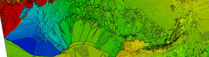
Topographic Maps
Preliminary topographic maps can be performed to identify significant surface features of a property and depict primary features and elevations. It uses global positioning system (GPS), electronic distance measurement (EDM) to show elevation change and landforms.

Sample topographic map
3-D Models
3-D Models allow full virtual visualization of a site area or structure. 3D work products include Point Clouds, 3D Mesh Models, and more. These models can be used for measurement or to superimpose CAD designs onto the current project site surroundings.

Sample 3-d image
Service Areas
Lighthouse employs FAA certified drone pilots in the following states: Florida, Georgia, Illinois, Indiana, Iowa, Kentucky, Louisiana, Michigan, Minnesota, North Carolina, Ohio, South Carolina, Texas, and Wisconsin. If your project is located in an area not on this list, contact us and we may be able to help you with your project through our alliance team of experienced coastal professionals.